Allhallows project in the fields - Reference MC/26/0001
The Allhallows project in the fields refers to a major and highly debated outline planning application submitted by Catesby Estates to Medway Council for a 350-home development on agricultural land on the edge of Allhallows village, Kent
The Catesby Estates "Fields" Project Overview
- Scale: Up to 350 new build properties
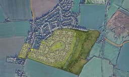
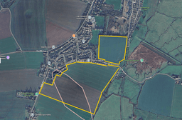
- Location: Earmarked on 26.27 hectares of farmland at the southern edge of the village, specifically spanning across fields off Stoke Road, Binney Road, and Dairy Fields Close.
- Layout split: The plans designate 320 houses on the east side of Stoke Road and 30 houses on the west side.
- Mix of properties: Designed to feature 46 one-bed flats/bungalows, 139 two-bed properties, 113 three-bed houses, and 52 four-bed homes.
- Affordable housing: Incorporates a 30% affordable housing allocation (105 homes), split between affordable rent and home ownership.
- Community amenities: Plans include space for a children’s day nursery, community allotments, a mobility hub with EV charging points, and an expansion of the Allhallows Burial Ground.
Project Status & Local Controversy
This development faces intense opposition from local residents and action groups. The village currently contains only about 700 households, meaning this project would increase the local population by 50%.
Locals are fighting the project through the Medway Council planning portal due to over-strained infrastructure—notably frequent village power outages, a lack of a GP surgery, and threats to protected wildlife like skylarks nesting in the fields. Planning committee review meetings and resident representation windows are actively shaping whether the project gets a green light or faces total refusal.
"The proposed 350-home development on the Stoke Road and Binney Road agricultural fields must be rejected because it represents an unsustainable expansion that permanently destroys vital greenfield land, worsens existing surface-water flood risks, and places an unmanageable burden on the Hoo Peninsula's severely isolated medical, educational, and transport infrastructure, thereby fundamentally undermining the quality of life for current residents."
Infrastructure Capacity Deficit
- Primary Care: The Hoo Peninsula suffers from a critical shortage of GP surgeries. Adding up to 1,000 new residents will push local healthcare services past breaking point.
- School Places: Local primary and secondary schools are already operating at or near capacity. The development offers no concrete funding to build new classrooms.
- Gridlock: The single-lane access roads connecting Allhallows to the A228 are already congested. This project will introduce hundreds of commuter vehicles to a fragile road network.
Environmental and Flooding Risks
- Loss of Productive Farmland: Converting 26 hectares of active agricultural greenfield into housing directly threatens local food security and permanently alters the rural character of the village.
- Surface Runoff: Replacing natural fields with impermeable concrete and tarmac increases surface-water runoff. Despite the removal of the northern field from the plans, the site risks displacing floodwaters directly onto surrounding properties, like those on Dairy Fields Close.
Isolation and Car Dependency
- Failed Sustainability Goals: Allhallows lacks the robust public transport links required for sustainable development. Future residents will be entirely dependent on private cars for shopping, work, and secondary education, completely contradicting local environmental and carbon-reduction targets.
Linked item location
me39nu
Attached images